The Northern Sea Route is a route through Arctic waters from Europe to Asia via the Arctic Ocean. It connects the Atlantic and Pacific Oceans and bypasses the coasts of Russia, Scandinavia, Greenland and Canada. It is one of the shortest sea routes between Asia and Europe, significantly reducing the time it takes to deliver goods to North Asia.
The Northern Sea Route is a relatively new route for commercial shipping. It was first sailed in 1935. However, the number of ships transiting the Northern Sea Route has only started to increase since 2010. In 2020, the number of vessels transiting increased to 319, 17% more than in 2019.
The Northern Sea Route, like any other Arctic route, poses significant dangers to ships and crews due to difficult weather conditions and ice. For this reason, the straits that make up the Northern Sea Route are regularly closed to commercial shipping.
The outlook for shipping along the Northern Sea Route is not bad. With global warming and the melting of the Arctic sea ice, the length of the Arctic waters in this region has shortened considerably, reducing the time and cost of transporting goods between Europe and Asia. In the longer term, we can also talk about supplying the African continent with goods via European ports, which is becoming increasingly important in the current geopolitical climate.
The number of ships transiting the Northern Sea Route is expected to continue to grow, especially as the value of oil and gas produced in the Arctic declines. This opens up new opportunities for other economic sectors such as tourism and fisheries.
Keel Holmen, director of the Norwegian Polar Institute (NPI), said after drilling in the Arctic in 2012: "This is a bigger change than we could have imagined 20 or even 10 years ago. What is happening has taken us by surprise and we need to change our perception of the system, put aside the scientific approach and adapt our senses to the changing environment".
Predicting exactly when and to what extent the northern seas will be ice-free is problematic - this is not a weekly forecast - but the trend is clear. The US Department of Defense predicts that by 2020 the Bering Strait will be ice-free 160 days a year (plus 35-45 days in spring and autumn). According to Norwegian scientists, there will be no ice at all in the Arctic by 2080.
The Northern Sea Route in Facts and Figures
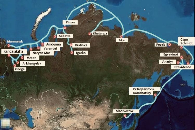
The Northern Sea Route starts in the ice-free port of Murmansk and runs through the Barents, Kara, Laptev, East Siberian and Chukchi Seas to the port of Provideniya. In a broader sense, St Petersburg and Vladivostok can be seen as the beginning and end of the route, although they are much further south. Nevertheless, they, rather than Murmansk and Provideniya, are among the most important hubs of modern Russia in terms of maritime transport. In this case, the Bering Sea should be added to the Northern Sea Route area.
The largest ports on the Northern Sea Route are, in order (St Petersburg) - Murmansk - Arkhangelsk - Mezen - Naryan-Mar - Varandey - Amderma - Sabetta - (Igarka) - Dudinka - Dikson - Khatanga - Tiksi - Cape Green - Pevek - Cape Schmidt - Providence - (Egvekinot - Anadyr - Petropavlovsk-Kamchatskiy - Magadan - Korsakov - Vanino - Nakhodka - Vladivostok). In total, there are about 70 transhipment points and ports along the Northern Sea Route, some of which are not directly on the coast but inland (e.g. Dudinka and Igarka are on the Yenisei River, several hundred kilometres from the Kara Sea coast, and the port of Khatanga is on the Khatanga River). Of course, it is also possible to connect the Northern Sea Route to Europe, which would provide additional options for delivering goods from China to Europe, for example, but this does not mean that the transit time is short.
Sailing season: July-October, i.e. for 2-4 months of the year the traffic is unhindered, the rest of the time it has to be accompanied by nuclear-powered icebreakers.
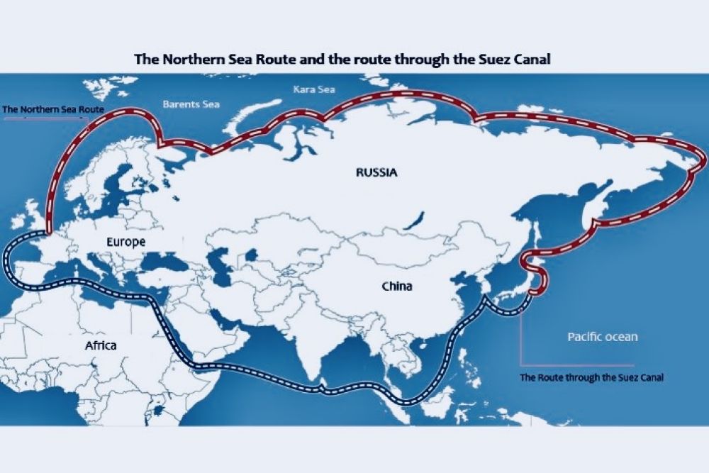
Length of the Northern Sea Route compared to other routes: Yokohama to Hamburg
1. Via the Northern Sea Route: 14.280 km
2. Via the Suez Canal: 23.200 km
3. Through the Cape of Good Hope: 29.400 km
Although glacier melt is thought to be the main driver for the reopening of the NSR, ice still covers the Arctic seas for most of the year (November to July), making year-round transport without icebreakers currently impossible.
Disadvantages and risks of the current project
In view of the above, it can be said that the Northern Sea Route has clear development prospects in the coming years. However, there are of course a number of advantages and disadvantages.
The cost of delivery is about 30% higher than the cost of transport via the traditional Suez Canal. Nevertheless, given the current situation in the Red Sea, it may be an interesting alternative.
Short voyage - the sailing season is only 4 months per year. Difficult navigation in some areas - the ice is quite solid and there will be some reliance on icebreaker escorts.
There is also another very important factor - high cargo insurance. However, it is expected that this route will develop actively in the coming years.